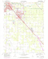
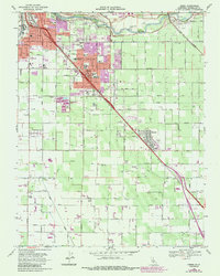
1969 Map of Ceres
USGS Topo · Published 1978About this map
The Tuolumne River defines the northern edge of this Central Valley landscape, where intensive agricultural irrigation systems meet the growing urban footprints of Ceres and Keyes. The map reveals a complex network of lateral canals and drains supporting the surrounding orchards and fields, intersected by three major rail lines: the Southern Pacific, the Tidewater Southern, and the Atchison Topeka and Santa Fe. This intersection of rail and water infrastructure underscores the region's historical role as a primary shipping hub for California produce. Notable local landmarks include the Modesto City-County Airport and the County Memorial Hospital. Cultural and educational centers like the Modesto Union Academy, White Sch, and the Faith Home Teen Ranch reflect the community's mid-century development. Smaller rural clusters like Yoris Grove and industrial markers such as the Grain Elevator provide specific points of interest for local historians.
Find a feature on this map
41 named features on this map. Tap any name to fly to it.
Don’t see what you’re looking for? This feature index may not catch every label — zoom into the map to look around manually.
Map Details
Editions of this 1969 Ceres Map
5 editions found
Other maps of this area

1915 · Westport
USGS Topo · 1:31,680

1915 · Salida
USGS Topo · 1:31,680

1916 · Mitchell School
USGS Topo · 1:31,680

1916 · Crows Landing
USGS Topo · 1:31,680

1916 · Riverbank
USGS Topo · 1:31,680

1916 · Denair
USGS Topo · 1:31,680

1916 · Waterford
USGS Topo · 1:31,680

1916 · Ceres
USGS Topo · 1:31,680

1917 · Turlock
USGS Topo · 1:31,680

1919 · Orestimba
USGS Topo · 1:62,500