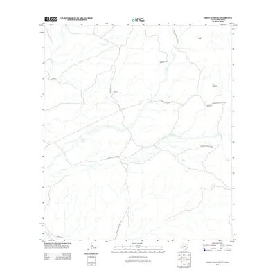
2013 Map of Cerro Redondo
USGS Topo · Published 2013About this map
Big Bend Ranch State Park dominates this desert landscape, where water sources dictate the placement of human infrastructure. Remote water improvements such as the Black Hills Creek Windmill, Gavino Windmill, and Gavino Tank provide essential resources in a region defined by arid drainage systems like Alamito Cr and Terneros Cr. The southern border follows the course of the Rio Grande, while several natural water points including Rabago y Teran Springs, Calera Spring, and Canoa Larga Spring emerge from the basin floor. The terrain rises toward the prominent peak of Cerro Redondo and the Black Hills, with Ranch Road 170 providing the primary transit route through this borderland territory.
Find a feature on this map
18 named features on this map. Tap any name to fly to it.
Don’t see what you’re looking for? This feature index may not catch every label — zoom into the map to look around manually.
Map Details
Editions of this 2013 Cerro Redondo Map
This is the sole edition of this map. No revisions or reprints were ever made.
Other maps of this area

1896 · Polvo
USGS Topo · 1:125,000

1896 · Shafter
USGS Topo · 1:125,000

1959 · Presidio
USGS Topo · 1:250,000

1965 · Presidio
USGS Topo · 1:250,000
1971 · Agua Adentro Mountain
USGS Topo · 1:24,000
1971 · Redford
USGS Topo · 1:24,000

1978 · La Boquilla
USGS Topo · 1:24,000

1979 · Presidio East
USGS Topo · 1:24,000

1983 · Cerro Redondo
USGS Topo · 1:24,000
1983 · Casa Piedra
USGS Topo · 1:24,000