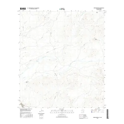
2016 Map of Cerro Redondo
USGS Topo · Published 2016About this map
Cerro Redondo rises as a prominent landmark in this desert landscape along the border of Presidio County, Texas, and Mexico. The terrain is defined by a network of seasonal watercourses and drainage systems, including the long reaches of Black Hills Creek and Terneros Creek. These waterways, along with Alamito Cr, dictate the movement through the region, where historical routes like Casa Piedra and Bofecillos Rd navigate the uneven elevation. A critical water source in this arid environment is found at Rabago y Teran Springs, while the southern portion of the map is marked by the distinctive Arroyo Palo Blanco. This 2016 survey provides a detailed view of the infrastructure and natural features just north of the Rio Grande, where the Black Hills and other geological formations create a complex topography typical of the Big Bend region.
Find a feature on this map
16 named features on this map. Tap any name to fly to it.
Don’t see what you’re looking for? This feature index may not catch every label — zoom into the map to look around manually.
Map Details
Editions of this 2016 Cerro Redondo Map
This is the sole edition of this map. No revisions or reprints were ever made.
Other maps of this area

1896 · Polvo
USGS Topo · 1:125,000

1896 · Shafter
USGS Topo · 1:125,000

1959 · Presidio
USGS Topo · 1:250,000

1965 · Presidio
USGS Topo · 1:250,000
1971 · Agua Adentro Mountain
USGS Topo · 1:24,000
1971 · Redford
USGS Topo · 1:24,000

1978 · La Boquilla
USGS Topo · 1:24,000

1979 · Presidio East
USGS Topo · 1:24,000

1983 · Cerro Redondo
USGS Topo · 1:24,000
1983 · Casa Piedra
USGS Topo · 1:24,000