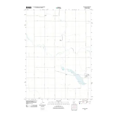
2010 Map of Ceylon
USGS Topo · Published 2010About this map
Ceylon serves as the central hub of this agricultural landscape in southern Minnesota, just north of the Iowa border. The town is anchored by the Ceylon Post Office and sits adjacent to a distinctive cluster of water bodies including Clear Lake, Susan Lake, and Fish Lake. The map reveals an intensive water management history, evidenced by the presence of Judicial Ditch Number Fifty and County Ditch Number Eleven, which channel water across the flat terrain. Evidence of the region’s natural transformations can be found at the Smith Lakebed, while the East Fork Des Moines River meanders across the western and northern sections of the quadrangle. Genealogists will find three significant burial grounds preserved here: Lone Cedar Cemetery in the north, Lake Belt Cemetery near the lakes, and Ellsworth Cemetery along the southern boundary.
Find a feature on this map
33 named features on this map. Tap any name to fly to it.
Don’t see what you’re looking for? This feature index may not catch every label — zoom into the map to look around manually.
Map Details
Editions of this 2010 Ceylon Map
This is the sole edition of this map. No revisions or reprints were ever made.
Other maps of this area

1954 · Fairmont
USGS Topo · 1:250,000

1958 · Fairmont
USGS Topo · 1:250,000

1970 · Ceylon
USGS Topo · 1:24,000

1970 · Welcome
USGS Topo · 1:24,000

1970 · Dunnell
USGS Topo · 1:24,000

1970 · Wilbert
USGS Topo · 1:24,000

1970 · Sherburn
USGS Topo · 1:24,000
1970 · Alpha
USGS Topo · 1:24,000

1972 · Estherville
USGS Topo · 1:24,000

1980 · Gruver
USGS Topo · 1:24,000