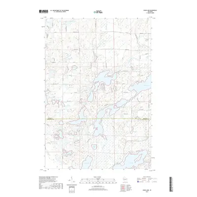
2018 Map of Chain Lake
USGS Topo · Published 2018About this map
Potato Creek and McDermott Creek carve through a densely lake-strewn landscape along the border of Rusk and Chippewa counties. This glacial terrain is defined by a high concentration of small kettle lakes and wetlands, connected by a network of local roads such as Horseshoe Lake Rd and Buck Lake Rd. The map reveals a cluster of uniquely named water bodies, from Dead Goose Lake and Hungry Lake to the prominent McCann Lake in the east. Notable landmarks like Deer Head Pt and secluded spots like Calkins Lake illustrate the area's geography before further modern development. The drainage patterns of Potato Cr and its tributaries suggest the historical importance of these waterways for the local timber and recreation economy in this part of Wisconsin.
Find a feature on this map
110 named features on this map. Tap any name to fly to it.
Don’t see what you’re looking for? This feature index may not catch every label — zoom into the map to look around manually.
Map Details
Editions of this 2018 Chain Lake Map
This is the sole edition of this map. No revisions or reprints were ever made.
Other maps of this area

1948 · Weyerhauser
USGS Topo · 1:48,000

1949 · Bloomer
USGS Topo · 1:62,500

1949 · New Auburn
USGS Topo · 1:62,500

1950 · Weyerhauser
USGS Topo · 1:48,000

1951 · Bloomer
USGS Topo · 1:62,500

1951 · New Auburn
USGS Topo · 1:62,500

1951 · Chetek
USGS Topo · 1:62,500

1953 · Rice Lake
USGS Topo · 1:250,000

1959 · Rice Lake
USGS Topo · 1:250,000
1972 · Fireside Lakes
USGS Topo · 1:24,000