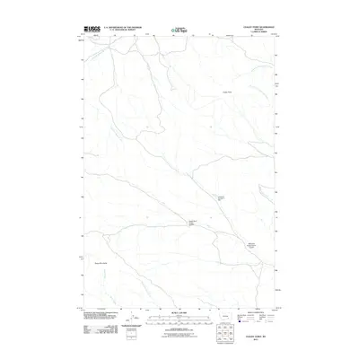
2011 Map of Chalky Point
USGS Topo · Published 2011About this map
The Sarpy Mountains anchor this portion of Big Horn County, Montana, defining a landscape of high ridges and branching drainage systems. This 2011 survey illustrates the complex topography of the high plains, where the Chalky Point overlook stands above a network of seasonal and perennial waterways. The distribution of water resources is a primary focal point, evidenced by the presence of the Cheyenne Number 5 Dam and the various forks of East Fork Sarpy Creek and Butte Creek. Historically significant naming conventions are visible in the numerous coulees, such as North Fork Indian Coulee and Williams Prong Indian Coulee, which trace the natural routes through the broken terrain. This map serves as a contemporary record of the land within the Busby District, highlighting the remote and geographically distinct character of the region before further modern developments altered these traditional drainage basins.
Find a feature on this map
11 named features on this map. Tap any name to fly to it.
Don’t see what you’re looking for? This feature index may not catch every label — zoom into the map to look around manually.
Map Details
Editions of this 2011 Chalky Point Map
This is the sole edition of this map. No revisions or reprints were ever made.
Other maps of this area

1954 · Hardin
USGS Topo · 1:250,000

1957 · Hardin
USGS Topo · 1:250,000

1958 · Hardin
USGS Topo · 1:250,000

1958 · Chalky Point
USGS Topo · 1:24,000

1958 · Painted Hill
USGS Topo · 1:24,000

1958 · Black Spring
USGS Topo · 1:24,000

1958 · Busby
USGS Topo · 1:24,000

1967 · Jeans Fork NE
USGS Topo · 1:24,000
1967 · Jeans Fork SE
USGS Topo · 1:24,000

1971 · Rough Draw
USGS Topo · 1:24,000