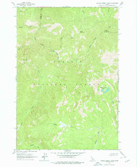
1963 Map of Challis Creek Lakes
USGS Topo · Published 1978About this map
Challis National Forest dominates this high-elevation landscape along the boundary of Custer and Lemhi Counties. The 1963 field check records a region defined by its steep drainage systems and legacy of extraction, most notably at the Parker Mine and Parker Mill situated on the slopes of Parker Mountain. These sites represent the historical mining activity that once drove the local economy, centered around the upper reaches of Kerr Creek.
Find a feature on this map
21 named features on this map. Tap any name to fly to it.
Don’t see what you’re looking for? This feature index may not catch every label — zoom into the map to look around manually.
Map Details
Editions of this 1963 Challis Creek Lakes Map
2 editions found
Other maps of this area

1919 · Custer
USGS Topo · 1:125,000

1922 · Custer
USGS Topo · 1:125,000

1929 · Bayhorse
USGS Topo · 1:125,000

1930 · Casto
USGS Topo · 1:125,000

1956 · Twin Peaks
USGS Topo · 1:62,500

1957 · Challis
USGS Topo · 1:250,000

1960 · Challis
USGS Topo · 1:250,000

1963 · Challis
USGS Topo · 1:250,000

1963 · Challis Creek Lakes
USGS Topo · 1:24,000

1963 · Custer
USGS Topo · 1:24,000