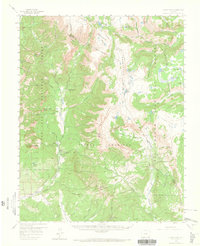
1957 Map of Chama Peak
USGS Topo · Published 1965About this map
The Continental Divide carves through the high country of the San Juan Mountains, separating the watersheds of the Rio Chama and the Conejos River in this mid-century survey of the Colorado-New Mexico borderlands. This landscape is defined by its massive private and public land holdings, most notably the southern expanse of the Tierra Amarilla Grant Boundary and the operations at Banded Peak Ranch.
Find a feature on this map
50 named features on this map. Tap any name to fly to it.
Don’t see what you’re looking for? This feature index may not catch every label — zoom into the map to look around manually.
Map Details
Editions of this 1957 Chama Peak Map
4 editions found

Other maps of this area

1913 · Summitville
USGS Topo · 1:125,000

1915 · Summitville
USGS Topo · 1:125,000

1918 · Tusas
USGS Topo · 1:125,000

1922 · Conejos
USGS Topo · 1:125,000

1945 · Durango
USGS Topo · 1:250,000

1953 · Durango
USGS Topo · 1:250,000

1954 · Durango
USGS Topo · 1:250,000

1954 · Aztec
USGS Topo · 1:250,000

1955 · Chama
USGS Topo · 1:62,500

1955 · Lumberton
USGS Topo · 1:62,500