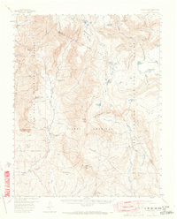
1957 Map of Chama Peak
USGS Topo · Published 1965About this map
Continental Divide crests through this high-altitude landscape of southern Colorado, marking the watershed between the Rio Chama and the Conejos River. The 1957 field check records a region defined by its isolation and specialized land use, notably the Gramps Oil Field located deep within the Tierra Amarilla grant. This private landholding, along with the San Juan National Forest and Rio Grande National Forest, characterizes the northern boundary of the historic New Mexico territory. Human presence is sparse, concentrated at the Banded Peak Ranch and its Upper Camp, linked by established routes like the Fish Lake Trail. The map details a complex network of high lakes such as Victoria Lake and Laguna Ruybal, serving as a record of the wilderness just before modern road expansion transformed the approach to the San Juan Mountains.
Find a feature on this map
55 named features on this map. Tap any name to fly to it.
Don’t see what you’re looking for? This feature index may not catch every label — zoom into the map to look around manually.
Map Details
Editions of this 1957 Chama Peak Map
4 editions found

Other maps of this area

1913 · Summitville
USGS Topo · 1:125,000

1915 · Summitville
USGS Topo · 1:125,000

1918 · Tusas
USGS Topo · 1:125,000

1922 · Conejos
USGS Topo · 1:125,000

1945 · Durango
USGS Topo · 1:250,000

1953 · Durango
USGS Topo · 1:250,000

1954 · Durango
USGS Topo · 1:250,000

1954 · Aztec
USGS Topo · 1:250,000

1955 · Chama
USGS Topo · 1:62,500

1955 · Lumberton
USGS Topo · 1:62,500