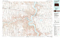
1986 Map of Chamberlain
USGS Topo · Published 1989About this map
The Missouri River corridor dominates this mid-1980s landscape, where the waters of Lake Francis Case separate the riverfront towns of Chamberlain and Oacoma. This region, where the White River flows eastward to join the Missouri, reflects a late-century transition from traditional agriculture toward water-based infrastructure. North of the river, the Crow Creek Indian Reservation and Lower Brule Indian Reservation border the reservoir, while inland settlements like Kennebec, Reliance, and Pukwana trace the path of Interstate 90 and the Chicago Milwaukee St Paul and Pacific railroad. The southern terrain rises toward the prominent Bijou Hills, surrounded by a network of small ranching communities including Ola and Bijou Hills. Numerous State Game Production Areas are scattered throughout, indicating the importance of land conservation and hunting in this portion of South Dakota.
Find a feature on this map
73 named features on this map. Tap any name to fly to it.
Don’t see what you’re looking for? This feature index may not catch every label — zoom into the map to look around manually.
Map Details
Editions of this 1986 Chamberlain Map
2 editions found
Other maps of this area

1935 · Chamberlain
USGS Topo · 1:62,500

1939 · Chamberlain
USGS Topo · 1:62,500

1940 · Iona
USGS Topo · 1:62,500

1941 · Pukwana
USGS Topo · 1:62,500

1941 · Kimball North
USGS Topo · 1:62,500

1944 · Iona
USGS Topo · 1:62,500

1951 · Presho 4 NE
USGS Topo · 1:24,000

1951 · Pukwana
USGS Topo · 1:62,500

1951 · Ideal NW
USGS Topo · 1:24,000

1951 · Ideal NE
USGS Topo · 1:24,000