
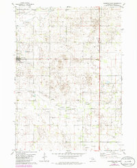
1981 Map of Chambers East
USGS Topo · Published 1981About this map
Chambers sits at the western edge of this landscape, characterized by the winding path of the South Fork Elkhorn River in the north and the intermittent flow of Dry Creek to the south. This 1981 survey reveals a rural Nebraska community organized around local aviation and community spaces, featuring the Perkins Memorial Airpark and Perkins Memorial Park directly adjacent to the town site. The map captures a high density of groundwater infrastructure, noting numerous Flowing Wells and individual wells scattered across the agricultural sections. These features, along with the Sewage Disposal Ponds and a prominent Radio Tower, reflect the essential utility and transport hubs of Holt County during the late twentieth century. Further east, a small Roadside Park along the highway provides a transition between the settled town and the open drainage basins of the sandhills region.
Find a feature on this map
11 named features on this map. Tap any name to fly to it.
Don’t see what you’re looking for? This feature index may not catch every label — zoom into the map to look around manually.
Map Details
Editions of this 1981 Chambers East Map
2 editions found
Other maps of this area

1955 · O'Neill
USGS Topo · 1:250,000

1959 · O'Neill
USGS Topo · 1:250,000

1964 · O'Neill SE
USGS Topo · 1:24,000

1964 · Emmet SE
USGS Topo · 1:24,000

1964 · O'Neill SW
USGS Topo · 1:24,000

1969 · O'Neill
USGS Topo · 1:250,000

1981 · Goose Lake SW
USGS Topo · 1:24,000
1981 · Goose Lake NE
USGS Topo · 1:24,000
1981 · Goose Lake
USGS Topo · 1:24,000
1981 · Miles Ranch
USGS Topo · 1:24,000