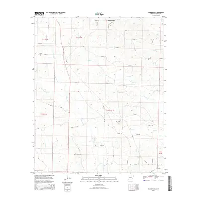
2014 Map of Chambersville
USGS Topo · Published 2014About this map
Chambersville anchors the northern landscape of this South Arkansas region, where the terrain is defined by a dense network of creek drainages. The winding course of Champagnolle Cr and its tributaries, including Little Champagnolle Cr and Whitewater Cr, carve through the land, creating a complex series of ridges and hollows. This topography is punctuated by Big Hill and the Bud Hill Lookout Tower, which served as a critical vantage point for forestry management and fire detection in the timber-heavy environment of Calhoun County.
Find a feature on this map
26 named features on this map. Tap any name to fly to it.
Don’t see what you’re looking for? This feature index may not catch every label — zoom into the map to look around manually.
Map Details
Editions of this 2014 Chambersville Map
This is the sole edition of this map. No revisions or reprints were ever made.
Other maps of this area

1903 · Camden
USGS Topo · 1:125,000

1953 · El Dorado
USGS Topo · 1:250,000

1957 · El Dorado
USGS Topo · 1:250,000

1958 · El Dorado
USGS Topo · 1:250,000

1960 · El Dorado
USGS Topo · 1:250,000

1966 · Kingsland
USGS Topo · 1:24,000

1966 · Fordyce
USGS Topo · 1:24,000

1973 · Bearden
USGS Topo · 1:24,000
1973 · Hampton
USGS Topo · 1:24,000
1973 · Woodberry
USGS Topo · 1:24,000