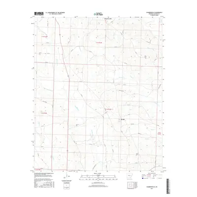
2017 Map of Chambersville
USGS Topo · Published 2017About this map
Chambersville and Big Hill anchor this rural landscape in Calhoun County, where a dense network of county roads and creek drainages reveals the persistent structure of Arkansas timberland and farming communities. The terrain is defined by the winding paths of Champagnolle Cr, Whitewater Cr, and Clear Cr, which carve through the varied topography of the Gulf Coastal Plain. For local historians and genealogists, the map provides precise locations for several family and community burial grounds, including Calaway Cem in the northwest, Oak Grove Cem in the northeast, and Newton Cem near the southern boundary. The inclusion of named thoroughfares like Turkey Ridge Rd and Hugh Jones Rd suggests the long-standing importance of these ridge-top and valley routes in connecting the isolated farmsteads and small settlements of the region.
Find a feature on this map
61 named features on this map. Tap any name to fly to it.
Don’t see what you’re looking for? This feature index may not catch every label — zoom into the map to look around manually.
Map Details
Editions of this 2017 Chambersville Map
This is the sole edition of this map. No revisions or reprints were ever made.
Other maps of this area

1903 · Camden
USGS Topo · 1:125,000

1953 · El Dorado
USGS Topo · 1:250,000

1957 · El Dorado
USGS Topo · 1:250,000

1958 · El Dorado
USGS Topo · 1:250,000

1960 · El Dorado
USGS Topo · 1:250,000

1966 · Kingsland
USGS Topo · 1:24,000

1966 · Fordyce
USGS Topo · 1:24,000

1973 · Bearden
USGS Topo · 1:24,000
1973 · Hampton
USGS Topo · 1:24,000
1973 · Woodberry
USGS Topo · 1:24,000