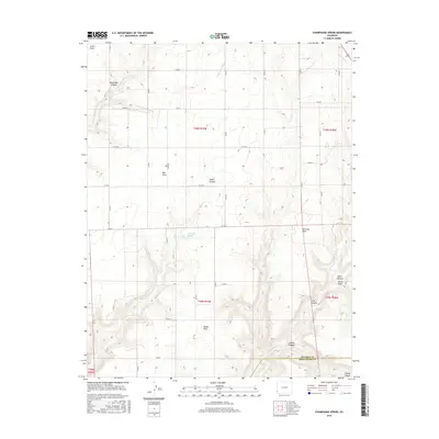
2016 Map of Champagne Spring
USGS Topo · Published 2016About this map
Champagne Spring and the surrounding high desert canyonlands of Montezuma and Dolores counties are meticulously documented in this modern survey. The terrain is defined by a series of dramatic geographic features, including Squaw Canyon, Cahone Canyon, and Monument Canyon, which carve through the plateau. Local landmarks such as Bug Point, McCloud Point, and Cedar Point serve as prominent navigational markers above the deep drainages. Water management and drainage patterns are central to the landscape, evidenced by the Dove Cr Canal and the course of Dove Cr. This map illustrates the transition from the relatively flat agricultural or rangeland mesa tops, gridded by a network of county roads like Co RD K and Co RD M, to the complex topographic relief of Alkali Draw and Cross Canyon.
Find a feature on this map
36 named features on this map. Tap any name to fly to it.
Don’t see what you’re looking for? This feature index may not catch every label — zoom into the map to look around manually.
Map Details
Editions of this 2016 Champagne Spring Map
This is the sole edition of this map. No revisions or reprints were ever made.
Other maps of this area

1886 · Abajo
USGS Topo · 1:250,000

1892 · Abajo
USGS Topo · 1:250,000

1893 · Abajo
USGS Topo · 1:250,000

1956 · Cortez
USGS Topo · 1:250,000

1957 · Cedar 3 NW
USGS Topo · 1:24,000

1957 · Cedar 3 SW
USGS Topo · 1:24,000

1957 · Monument Canyon
USGS Topo · 1:62,500
1957 · Eastland
USGS Topo · 1:62,500
1958 · Verdure 4 NE
USGS Topo · 1:24,000

1958 · Cortez
USGS Topo · 1:250,000