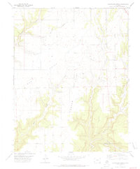
1978 Map of Champagne Spring
USGS Topo · Published 1979About this map
The high plateau of the Four Corners region is defined by deep incisions and prominent mesas along the Dolores Co Montezuma Co boundary. The landscape is characterized by its dramatic verticality, where the flat top of Bug Point and Squaw Point give way to the winding drainage of Squaw Canyon. This 1970s survey documents the hydrological importance of Champagne Spring, a critical water source in an otherwise arid system of canyons. Evidence of land use and resource extraction appears in the form of a Gravel Pit and scattered Drill Hole markers. The network of canyons, including Cross Canyon and Alkali Can, dictates the movement of both water and any historical transit through this portion of Dolores County.
Find a feature on this map
12 named features on this map. Tap any name to fly to it.
Don’t see what you’re looking for? This feature index may not catch every label — zoom into the map to look around manually.
Map Details
Editions of this 1978 Champagne Spring Map
This is the sole edition of this map. No revisions or reprints were ever made.
Other maps of this area

1886 · Abajo
USGS Topo · 1:250,000

1892 · Abajo
USGS Topo · 1:250,000

1893 · Abajo
USGS Topo · 1:250,000

1956 · Cortez
USGS Topo · 1:250,000

1957 · Cedar 3 NW
USGS Topo · 1:24,000

1957 · Cedar 3 SW
USGS Topo · 1:24,000

1957 · Monument Canyon
USGS Topo · 1:62,500
1957 · Eastland
USGS Topo · 1:62,500
1958 · Verdure 4 NE
USGS Topo · 1:24,000

1958 · Cortez
USGS Topo · 1:250,000