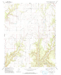
1993 Map of Champagne Spring
USGS Topo · Published 1994About this map
Squaw Point and Bug Point dominate the high ground of this corner of Colorado, where the plateaus are deeply incised by the drainage systems of Papoose Canyon and McCloud Canyon. This 1993 edition reveals a landscape of industrial extraction and agricultural water management at the Dolores and Montezuma county line. A designated Oil Field with numerous Gas Wells marks the southern territory, while the northern sections focus on water infrastructure such as the Dove Cr Canal and the Aqueduct. Local landmarks including the Dove Creek Pumping Sta and scattered Storage Bins point to the logistical requirements of this high-desert environment. The namesake Champagne Spring is located centrally, providing a historical water source in a region otherwise defined by seasonal washes like Monument Creek and the meandering Dove Creek.
Find a feature on this map
26 named features on this map. Tap any name to fly to it.
Don’t see what you’re looking for? This feature index may not catch every label — zoom into the map to look around manually.
Map Details
Editions of this 1993 Champagne Spring Map
This is the sole edition of this map. No revisions or reprints were ever made.
Other maps of this area

1886 · Abajo
USGS Topo · 1:250,000

1892 · Abajo
USGS Topo · 1:250,000

1893 · Abajo
USGS Topo · 1:250,000

1956 · Cortez
USGS Topo · 1:250,000

1957 · Cedar 3 NW
USGS Topo · 1:24,000

1957 · Cedar 3 SW
USGS Topo · 1:24,000

1957 · Monument Canyon
USGS Topo · 1:62,500
1957 · Eastland
USGS Topo · 1:62,500
1958 · Verdure 4 NE
USGS Topo · 1:24,000

1958 · Cortez
USGS Topo · 1:250,000