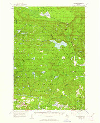
1955 Map of Champion
USGS Topo · Published 1963About this map
Mining and timber production define this mid-century landscape on the border of Baraga and Marquette Counties. While the northern reaches are dominated by the Yellow Dog Plains and the dense Michigan State Forest, the southern portion reveals a concentrated industrial corridor. Here, the Duluth South Shore and Atlantic Railroad connects the settlements of Champion and Diorite, supporting a network of extraction sites including the Blueberry Mine and the Michigan Gold Mine. A notable geographic feature is the Silver Lake Basin, which sits at the headwaters of Voelkers Creek. The transition from the massive Mulligan Swamp in the north to the refined railroad grades near Clowry illustrates the mid-century balance between wilderness and the region's mineral-driven economy.
Find a feature on this map
68 named features on this map. Tap any name to fly to it.
Don’t see what you’re looking for? This feature index may not catch every label — zoom into the map to look around manually.
Map Details
Editions of this 1955 Champion Map
4 editions found

Other maps of this area

1899 · Witbeck
USGS Topo · 1:62,500

1952 · Ishpeming
USGS Topo · 1:62,500

1952 · Ishpeming
USGS Topo · 1:24,000

1954 · Negaunee SW
USGS Topo · 1:24,000

1954 · Negaunee
USGS Topo · 1:62,500

1954 · Huron Mountain
USGS Topo · 1:62,500

1954 · Big Bay
USGS Topo · 1:62,500

1954 · Skanee
USGS Topo · 1:62,500

1955 · Champion
USGS Topo · 1:24,000

1955 · Diorite
USGS Topo · 1:24,000