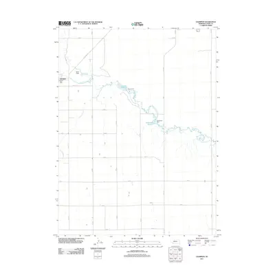
2011 Map of Champion
USGS Topo · Published 2011About this map
Frenchman Creek meanders through this portion of Chase County, Nebraska, serving as the central hydrological feature for a landscape defined by agricultural water management. The settlement of Champion is positioned on the western edge of the sheet, featuring the Champion Post Office and providing a focal point for the surrounding rural section lines. Water infrastructure is prominent along the creek's path, notably at Imperial Reservoir, which is held by the Imperial Dam, and further downstream at Hoffmeister Reservoir and Hoffmeister Dam. The terrain is characterized by draws and intermittent drainage, including the Sand Draw and Foerster Branch, which cut through the high plains toward the river valley. A rigid grid of county roads and State Hwy 15 A facilitates transport across this productive western Nebraska landscape.
Find a feature on this map
24 named features on this map. Tap any name to fly to it.
Don’t see what you’re looking for? This feature index may not catch every label — zoom into the map to look around manually.
Map Details
Editions of this 2011 Champion Map
This is the sole edition of this map. No revisions or reprints were ever made.
Other maps of this area

1954 · McCook
USGS Topo · 1:250,000

1957 · McCook
USGS Topo · 1:250,000

1958 · McCook
USGS Topo · 1:250,000

1973 · Champion
USGS Topo · 1:24,000
1973 · Chase
USGS Topo · 1:24,000

1973 · Enders
USGS Topo · 1:24,000

1973 · Champion SW
USGS Topo · 1:24,000

1973 · Imperial
USGS Topo · 1:24,000

1973 · Reservoir Lake SE
USGS Topo · 1:24,000

1973 · Ough
USGS Topo · 1:24,000