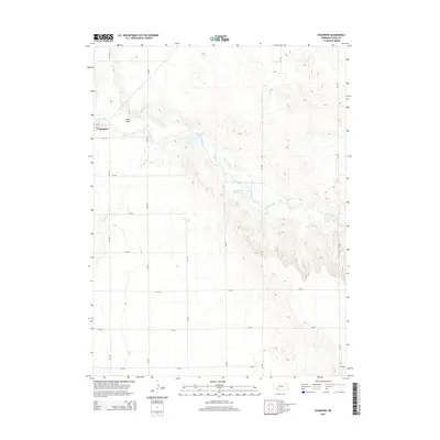
2014 Map of Champion
USGS Topo · Published 2014About this map
Champion sits at the northwestern edge of this Chase County landscape, situated near the confluence of Frenchman Cr and Sand Draw. The geography is defined by the winding course of the creek as it carves through the High Plains, creating a distinct riparian corridor that contrasts with the surrounding agricultural grid. Key water management features such as Hoffmeister Reservoir and Reservoir Pond are visible along the waterway, reflecting the importance of irrigation and water storage in this part of Nebraska. The map detail shows a transition from the structured township roads like 328 Ave and 730 RD to the natural breaks and drainage of Foerster Br. This 2014 survey documents the enduring layout of rural sections and the localized water systems that sustain the community.
Find a feature on this map
21 named features on this map. Tap any name to fly to it.
Don’t see what you’re looking for? This feature index may not catch every label — zoom into the map to look around manually.
Map Details
Editions of this 2014 Champion Map
This is the sole edition of this map. No revisions or reprints were ever made.
Other maps of this area

1954 · McCook
USGS Topo · 1:250,000

1957 · McCook
USGS Topo · 1:250,000

1958 · McCook
USGS Topo · 1:250,000

1973 · Champion
USGS Topo · 1:24,000
1973 · Chase
USGS Topo · 1:24,000

1973 · Enders
USGS Topo · 1:24,000

1973 · Champion SW
USGS Topo · 1:24,000

1973 · Imperial
USGS Topo · 1:24,000

1973 · Reservoir Lake SE
USGS Topo · 1:24,000

1973 · Ough
USGS Topo · 1:24,000