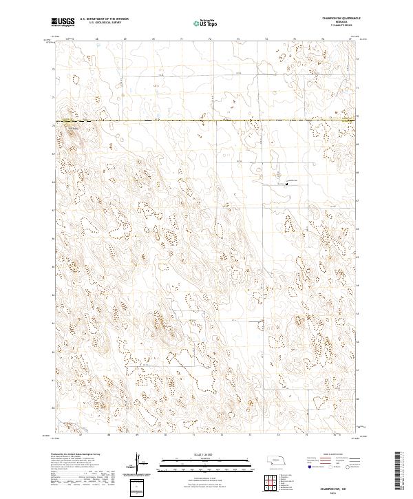
2021 Map of Champion SW
USGS Topo · Published 2021About this map
Hiawatha Cem is a lonely landmark in the northwestern corner of Dundy County, Nebraska, marking a legacy of early prairie settlement near the border of Chase County. The landscape is dominated by the subtle, undulating topography of the High Plains, where the most prominent natural feature is the high point known as Old Baldy. A network of section-line gravel roads, including RD 726, RD 724 A, and RD 720 A, provide a window into the land's division into township and range blocks. This area, largely devoid of modern development, preserves the spatial arrangement of the Great Plains at the start of the 2020s, reflecting a remote ranching and agricultural heritage where routes like Lutz Rd follow the contours of the open range.
Find a feature on this map
21 named features on this map. Tap any name to fly to it.
Don’t see what you’re looking for? This feature index may not catch every label — zoom into the map to look around manually.
Map Details
Editions of this 2021 Champion SW Map
This is the sole edition of this map. No revisions or reprints were ever made.
Other maps of this area

1954 · McCook
USGS Topo · 1:250,000

1957 · McCook
USGS Topo · 1:250,000

1958 · McCook
USGS Topo · 1:250,000

1973 · Champion
USGS Topo · 1:24,000
1973 · Haigler NE
USGS Topo · 1:24,000

1973 · Enders
USGS Topo · 1:24,000

1973 · Champion SW
USGS Topo · 1:24,000

1973 · Reservoir Lake SE
USGS Topo · 1:24,000

1973 · Ough
USGS Topo · 1:24,000
1973 · Benkelman NW
USGS Topo · 1:24,000