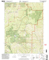
1998 Map of Chanchelulla Peak
USGS Topo · Published 2003About this map
Chanchelulla Peak dominates this mountainous portion of the Shasta-Trinity National Forests, where the rugged topography of the Klamath Mountains meets historical mining and ranching interests. Near the southwestern corner, the location of McKinley City (Site) serves as a reminder of early settlement attempts, while the presence of the Victory Mine and Midas Mine along the Harrison Gulch Road corridor points to the region's mineral prospecting past.
Find a feature on this map
47 named features on this map. Tap any name to fly to it.
Don’t see what you’re looking for? This feature index may not catch every label — zoom into the map to look around manually.
Map Details
Editions of this 1998 Chanchelulla Peak Map
This is the sole edition of this map. No revisions or reprints were ever made.
Other maps of this area

1890 · Red Bluff
USGS Topo · 1:250,000

1894 · Red Bluff
USGS Topo · 1:250,000

1909 · Big Bar
USGS Topo · 1:96,000

1913 · Weaverville
USGS Topo · 1:125,000

1915 · Big Bar and Vicinity
USGS Topo · 1:250,000

1931 · Hoaglin
USGS Topo · 1:96,000

1935 · Hoaglin
USGS Topo · 1:125,000

1950 · Weaverville
USGS Topo · 1:62,500

1951 · Hayfork
USGS Topo · 1:62,500

1951 · Chanchelulla Peak
USGS Topo · 1:62,500