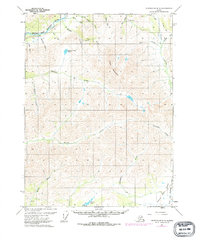
1971 Map of Chandalar B-6
USGS Topo · Published 1977About this map
The Trans-Alaska Pipeline cuts a straight path through the northwest corner of this subarctic landscape, reflecting a transformative moment in Alaskan infrastructure. Surveyed just as the energy corridor was being established, the map documents the Middle Fork Koyukuk River valley and its surrounding drainage systems. Low-lying flats in the southeast give way to the prominent Poss Mountain and a network of named waterways like Minnie Creek and Marion Creek.
Find a feature on this map
32 named features on this map. Tap any name to fly to it.
Don’t see what you’re looking for? This feature index may not catch every label — zoom into the map to look around manually.
Map Details
Editions of this 1971 Chandalar B-6 Map
2 editions found
Other maps of this area

1951 · Chandalar
USGS Topo · 1:250,000

1951 · Wiseman
USGS Topo · 1:250,000

1956 · Chandalar
USGS Topo · 1:250,000

1956 · Wiseman
USGS Topo · 1:250,000

1964 · Wiseman
USGS Topo · 1:250,000

1964 · Chandalar
USGS Topo · 1:250,000

1970 · Wiseman A-1
USGS Topo · 1:63,360
1970 · Chandalar A-6
USGS Topo · 1:63,360
1970 · Chandalar A-5
USGS Topo · 1:63,360

1971 · Chandalar B-5
USGS Topo · 1:63,360