1956 Map of Chandalar
USGS Topo · Published 1958About this map
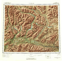
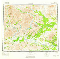
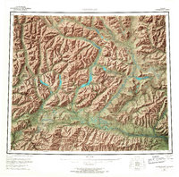
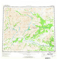
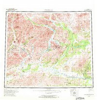
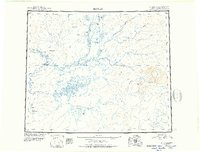
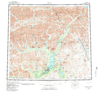
Venetie sits along the southern banks of the Chandalar River in this 1950s depiction of the central Brooks Range foothills. The map details a landscape dominated by the intricate drainage systems of the Middle Fork Chandalar River and the North Fork Koyukuk River, illustrating the rugged topography before modern development reached this interior region. Smaller settlements and waypoints like Caro and the Sixty-one Mile Cabin are visible, alongside a extensive Winter Trail that served as a vital transport artery for the remote north. The presence of the Venetie Indian Reservation in the southeast corner marks the cultural footprint of the Neets'ąįį Gwich'in people during this era of federal land mapping. This survey is particularly useful for identifying traditional landmarks like the O'Keefe Hills and the twin peaks of East Buttons and West Buttons which helped guide travel through the vast river valleys.
Find a feature on this map
36 named features on this map. Tap any name to fly to it.
Don’t see what you’re looking for? This feature index may not catch every label — zoom into the map to look around manually.
Map Details
Editions of this 1956 Chandalar Map
8 editions found

Other maps of this area
1951 · Fort Yukon
USGS Topo · 1:250,000
1951 · Bettles
USGS Topo · 1:250,000

1951 · Chandler Lake
USGS Topo · 1:250,000

1951 · Chandalar
USGS Topo · 1:250,000
1951 · Christian
USGS Topo · 1:250,000

1951 · Brooks
USGS Topo · 1:250,000
1951 · Beaver
USGS Topo · 1:250,000

1951 · Arctic
USGS Topo · 1:250,000
1951 · Wiseman
USGS Topo · 1:250,000
1956 · Arctic
USGS Topo · 1:250,000