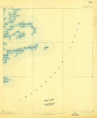
1893 Map of Chandeleur
USGS Topo · Published 1902About this map
Chandeleur Sound dominates this late nineteenth-century hydrographic study, illustrating the complex network of barrier islands and tidal passes along the Louisiana coast. Compiled by H.L. Baldwin Jr. from 1891 surveys, the map reveals a fragile landscape where narrow landforms like Mitchell Key and smaller outliers such as Barrel Key stand against the Gulf. The maritime character of the region is evident in the naming of critical navigation channels, including Elephant Point Pass and Keelboat Pass. Notable terrestrial features are sparse but significant for coastal history, including Martin Island, Holmes Island, and the land at Pt. Comfort. This sheet provides a baseline for understanding the geomorphology of the St. Bernard Parish shoreline before the significant coastal erosion of the twentieth century, detailing the exact configuration of Live Oak Bayou as it appeared during the J.W. Powell administration of the Geological Survey.
Find a feature on this map
11 named features on this map. Tap any name to fly to it.
Don’t see what you’re looking for? This feature index may not catch every label — zoom into the map to look around manually.
Map Details
Editions of this 1893 Chandeleur Map
3 editions found
Other maps of this area

1893 · Cat Island
USGS Topo · 1:62,500

1893 · La Fortuna
USGS Topo · 1:62,500

1893 · Chandeleur
USGS Topo · 1:62,500

1893 · Toulme
USGS Topo · 1:62,500

1895 · Bodreau
USGS Topo · 1:62,500

1935 · Morgan Harbor
USGS Topo · 1:31,680

1935 · Mitchell Keys
USGS Topo · 1:31,680

1946 · Oak Mound Bayou
USGS Topo · 1:31,680
1949 · Drum Bay
USGS Topo · 1:31,680
1949 · Door Point
USGS Topo · 1:31,680