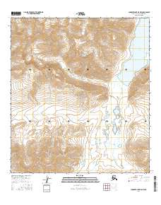
2016 Map of Chandler Lake A-5 NW
USGS Topo · Published 2016About this map
Gates Of The Arctic National Park encompasses this northern landscape, dominated by high elevations and Arctic watersheds. The eastern edge of the map features the expanse of Chandler Lake, from which the northward-flowing Chandler River originates. This high-altitude drainage system is further defined by tributaries such as Iklauyaurak Cr and Iklauyak Cr, which carve through the mountainous terrain. The map depicts a wilderness area defined by its hydrology and topographic relief, showing the relationship between the high lakes and the river systems that drain toward the Arctic coast. The survey captures the region's character through precise contouring and the identification of these major water bodies within the protected national park boundaries.
Find a feature on this map
9 named features on this map. Tap any name to fly to it.
Don’t see what you’re looking for? This feature index may not catch every label — zoom into the map to look around manually.
Map Details
Editions of this 2016 Chandler Lake A-5 NW Map
This is the sole edition of this map. No revisions or reprints were ever made.
Other maps of this area

1951 · Chandler Lake
USGS Topo · 1:250,000

1951 · Killik River
USGS Topo · 1:250,000

1956 · Chandler Lake
USGS Topo · 1:250,000

1956 · Killik River
USGS Topo · 1:250,000

1964 · Chandler Lake
USGS Topo · 1:250,000
1986 · Killik River A-1
USGS Topo · 1:63,360
1986 · Chandler Lake A-5
USGS Topo · 1:63,360
1986 · Killik River B-1
USGS Topo · 1:63,360
1987 · Chandler Lake B-5
USGS Topo · 1:63,360
2016 · Chandler Lake B-5 SW
USGS Topo · 1:25,000