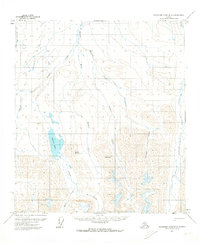
1971 Map of Chandler Lake B-2
USGS Topo · Published 1974About this map
Shainin Lake and the surrounding drainages of the Kanayut River define this high-altitude landscape on the North Slope. Surveyed in the early 1970s, the terrain is characterized by a complex network of glacial valleys and mountain summits, notably Mount Wachsmuth and the distinctive Ear Peak. The drainage patterns here are intricate, with Alapah Creek and Welcome Creek carving deep paths through the upland territory. This survey was produced by the U.S. Geological Survey using photogrammetric methods from 1970 aerial photography, providing a record of these remote waterways, including the Nanushuk River and Iknivik Creek, in their late-century state. The presence of features like Erratic Creek and Antler Valley Creek points to the naming conventions used by field annotators to describe the unique physical characteristics found within the Umiat Meridian.
Find a feature on this map
12 named features on this map. Tap any name to fly to it.
Don’t see what you’re looking for? This feature index may not catch every label — zoom into the map to look around manually.
Map Details
Editions of this 1971 Chandler Lake B-2 Map
This is the sole edition of this map. No revisions or reprints were ever made.
Other maps of this area

1951 · Chandler Lake
USGS Topo · 1:250,000

1956 · Chandler Lake
USGS Topo · 1:250,000

1964 · Chandler Lake
USGS Topo · 1:250,000
1971 · Chandler Lake A-2
USGS Topo · 1:63,360
1971 · Chandler Lake C-2
USGS Topo · 1:63,360
1971 · Chandler Lake A-1
USGS Topo · 1:63,360
1971 · Chandler Lake C-1
USGS Topo · 1:63,360

1971 · Chandler Lake A-3
USGS Topo · 1:63,360
1971 · Chandler Lake B-1
USGS Topo · 1:63,360
1987 · Chandler Lake C-3
USGS Topo · 1:63,360