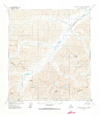
1971 Map of Chandler Lake A-1
USGS Topo · Published 1973About this map
The Continental Divide cuts through this high-altitude landscape of the Brooks Range, separating the northern and southern drainage systems of the North Slope. At the time of this 1970 aerial annotation, the region remained largely untouched by permanent development, though a lone Cabin near the North Fork Koyukuk River provides evidence of human presence in this high-mountain wilderness. The hydrography is dominated by the Itkillik River flowing through the Itkillik Valley and Oolah to the north, while the southern slopes feed the Koyukuk watershed. Significant peaks including Oolah Mountain, Oxadak Mountain, Inclined Mountain, and Snowheel Mountain anchor the terrain. The presence of Oolah Pass suggests a natural transit corridor through the otherwise formidable mountain ridges. This survey reflects the Bureau of Land Management's work in establishing land lines for unsurveyed and unmarked locations across the South Boundary Umiat Meridian.
Find a feature on this map
15 named features on this map. Tap any name to fly to it.
Don’t see what you’re looking for? This feature index may not catch every label — zoom into the map to look around manually.
Map Details
Editions of this 1971 Chandler Lake A-1 Map
2 editions found
Other maps of this area

1951 · Chandler Lake
USGS Topo · 1:250,000

1951 · Chandalar
USGS Topo · 1:250,000

1951 · Brooks
USGS Topo · 1:250,000

1951 · Wiseman
USGS Topo · 1:250,000

1956 · Chandalar
USGS Topo · 1:250,000

1956 · Wiseman
USGS Topo · 1:250,000

1956 · Philip Smith Mountains
USGS Topo · 1:250,000

1956 · Chandler Lake
USGS Topo · 1:250,000

1964 · Wiseman
USGS Topo · 1:250,000

1964 · Chandalar
USGS Topo · 1:250,000