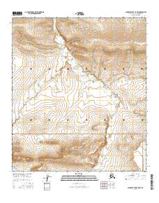
2016 Map of Chandler Lake C-5 NW
USGS Topo · Published 2016About this map
The Ayiyak River winds through this northern expanse of the Brooks Range, defining the drainage patterns of a landscape managed in part by the Gates of the Arctic National Park. High-elevation landmarks like Hatbox Mesa and the Canoe Hills rise above the surrounding valleys, providing significant topographic relief in an area devoid of permanent human settlements or infrastructure. The hydrology is marked by smaller seasonal flows such as Canoe Cr and Fortress Cr, which feed into the larger river systems.
Find a feature on this map
12 named features on this map. Tap any name to fly to it.
Don’t see what you’re looking for? This feature index may not catch every label — zoom into the map to look around manually.
Map Details
Editions of this 2016 Chandler Lake C-5 NW Map
This is the sole edition of this map. No revisions or reprints were ever made.
Other maps of this area

1951 · Chandler Lake
USGS Topo · 1:250,000

1951 · Killik River
USGS Topo · 1:250,000

1956 · Chandler Lake
USGS Topo · 1:250,000

1956 · Killik River
USGS Topo · 1:250,000

1964 · Chandler Lake
USGS Topo · 1:250,000
1986 · Killik River D-1
USGS Topo · 1:63,360
1986 · Killik River C-1
USGS Topo · 1:63,360
1987 · Chandler Lake C-5
USGS Topo · 1:63,360
1987 · Chandler Lake D-5
USGS Topo · 1:63,360
2016 · Chandler Lake D-5 SE
USGS Topo · 1:25,000