
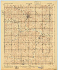
1907 Map of Chandler
USGS Topo · Published 1907About this map
Chandler serves as the central hub of this 1905 territory survey, just years before Oklahoma achieved statehood. The landscape is defined by the winding course of the Deep Fork Canadian River, which creates a complex drainage system fed by numerous tributaries like Bellcow Creek, Pecan Creek, and Quapaw Creek. A dense network of competing rail lines crisscrosses the county, including the Chicago Rock Island and Pacific and the St Louis and San Francisco, driving the growth of established towns like Davenport and smaller stops such as Daggett and Chuckaho.
Find a feature on this map
45 named features on this map. Tap any name to fly to it.
Don’t see what you’re looking for? This feature index may not catch every label — zoom into the map to look around manually.
Map Details
Editions of this 1907 Chandler Map
2 editions found
Other maps of this area

1896 · Seminole and Prague
USGS Topo · 1:125,000

1898 · Purcell
USGS Topo · 1:125,000

1905 · Chandler
USGS Topo · 1:62,500

1908 · Agra
USGS Topo · 1:62,500

1909 · Shawnee
USGS Topo · 1:62,500

1909 · Luther
USGS Topo · 1:62,500

1909 · Perkins
USGS Topo · 1:62,500

1929 · Stroud
USGS Topo · 1:62,500

1930 · McLoud
USGS Topo · 1:62,500

1931 · Drumright
USGS Topo · 1:62,500