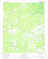
1965 Map of Chapel Hill
USGS Topo · Published 1978About this map
The Oklahoma Arkansas state line divides this 1960s landscape, where the Texas Oklahoma and Eastern railroad cuts through the southern timber and bottomlands. This survey documents the region just as the De Queen Dam (Under Constr) began altering the local geography. Blue hatching across the northeastern corner indicates the future footprint of the De Queen Lake reservoir, showing exactly which family lands and stream reaches along Story Creek were slated for inundation.
Find a feature on this map
40 named features on this map. Tap any name to fly to it.
Don’t see what you’re looking for? This feature index may not catch every label — zoom into the map to look around manually.
Map Details
Editions of this 1965 Chapel Hill Map
2 editions found
Other maps of this area

1902 · Lukfata
USGS Topo · 1:125,000

1913 · De Queen
USGS Topo · 1:125,000

1950 · Mcalester
USGS Topo · 1:250,000

1950 · Goodwater
USGS Topo · 1:24,000

1951 · Goodwater
USGS Topo · 1:24,000

1951 · Cerrogordo
USGS Topo · 1:24,000

1951 · Horatio
USGS Topo · 1:24,000

1953 · Texarkana
USGS Topo · 1:250,000

1956 · Texarkana
USGS Topo · 1:250,000

1959 · Broken Bow
USGS Topo · 1:62,500