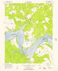
1953 Map of Charles City
USGS Topo · Published 1957About this map
Charles City serves as the focal point of this Tidewater landscape, where the James River forms a wide, sweeping bend known as the Threemile Reach. This 1950s survey documents a region defined by its long-standing plantation estates and river-oriented economy. Notable historical landmarks include Sherwood Forest Home of Pres Tyler and the site of Fort Powhatan on the southern bank. The river remains the primary geographic feature, characterized by numerous wharves like Buckland Wharf and Willcox Wharf that once served as vital transportation nodes.
Find a feature on this map
54 named features on this map. Tap any name to fly to it.
Don’t see what you’re looking for? This feature index may not catch every label — zoom into the map to look around manually.
Map Details
Editions of this 1953 Charles City Map
This is the sole edition of this map. No revisions or reprints were ever made.
Other maps of this area

1917 · Toano
USGS Topo · 1:62,500

1918 · Charles City
USGS Topo · 1:62,500

1918 · Toano
USGS Topo · 1:62,500

1919 · Surry
USGS Topo · 1:62,500

1919 · Disputanta
USGS Topo · 1:62,500

1943 · Savedge
USGS Topo · 1:31,680

1943 · Disputanta
USGS Topo · 1:31,680

1943 · Richmond
USGS Topo · 1:250,000

1949 · Richmond
USGS Topo · 1:250,000
1952 · Brandon
USGS Topo · 1:24,000