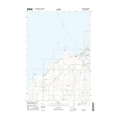
2017 Map of Charlevoix
USGS Topo · Published 2017About this map
Lake Michigan and its eastern shoreline dominate this 2017 study of the water-centric community around Charlevoix. The geography is defined by the narrow passage between the great lake and Lake Charlevoix, where Bridge St connects the town's residential and commercial districts. To the west, Fisherman Island and South Point protect the waters of Bells Bay, a landscape marked by the Fisherman's Island State Park - Foot Trail. Moving inland, the terrain transitions to the agricultural and rural stretches of Barnard and Clover. Genealogists will find significant local records preserved across several burial grounds, including Saint Marys Cem, Brookside Cem, and the Grand Army of the Republic Cem. The map also documents the transit network that sustains the region, from the Charlevoix Municipal Airport to the Beaver Island Ferry route heading northwest.
Find a feature on this map
67 named features on this map. Tap any name to fly to it.
Don’t see what you’re looking for? This feature index may not catch every label — zoom into the map to look around manually.
Map Details
Editions of this 2017 Charlevoix Map
This is the sole edition of this map. No revisions or reprints were ever made.
Other maps of this area
1954 · Central Lake
USGS Topo · 1:62,500
1954 · Charlevoix
USGS Topo · 1:62,500
1955 · Cheboygan
USGS Topo · 1:250,000
1958 · Cheboygan
USGS Topo · 1:250,000
1958 · Bayshore
USGS Topo · 1:62,500
1961 · Boyne City
USGS Topo · 1:62,500
1975 · Boyne City NW
USGS Topo · 1:24,000
1983 · Ellsworth
USGS Topo · 1:25,000
1983 · Atwood
USGS Topo · 1:24,000
1983 · Charlevoix
USGS Topo · 1:25,000