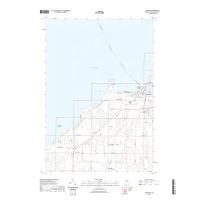
2019 Map of Charlevoix
USGS Topo · Published 2019About this map
Charlevoix serves as the focal point of this coastal landscape where the waters of Lake Michigan meet the inlet of Lake Charlevoix. The town's grid is detailed with residential streets such as Clinton St and Belvedere Ave, surrounding the Charlevoix County Building. A critical transport link is visible via the Beaver Island Ferry route, which tracks northwest into the open water. To the southwest, the shoreline transitions into the protected acreage of Fisherman's Island State Park, featuring the Fisherman's Island State Park Foot Trail and the eponymous Fisherman Island.
Find a feature on this map
64 named features on this map. Tap any name to fly to it.
Don’t see what you’re looking for? This feature index may not catch every label — zoom into the map to look around manually.
Map Details
Editions of this 2019 Charlevoix Map
This is the sole edition of this map. No revisions or reprints were ever made.
Other maps of this area

1954 · Central Lake
USGS Topo · 1:62,500

1954 · Charlevoix
USGS Topo · 1:62,500

1955 · Cheboygan
USGS Topo · 1:250,000

1958 · Cheboygan
USGS Topo · 1:250,000

1958 · Bayshore
USGS Topo · 1:62,500

1961 · Boyne City
USGS Topo · 1:62,500

1975 · Boyne City NW
USGS Topo · 1:24,000
1983 · Ellsworth
USGS Topo · 1:25,000
1983 · Atwood
USGS Topo · 1:24,000
1983 · Charlevoix
USGS Topo · 1:25,000