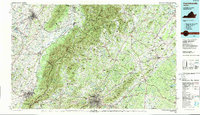
1986 Map of Charlottesville
USGS Topo · Published 1989About this map
Monticello and the historic grounds of the University of Virginia anchor the southeastern portion of this landscape, reflecting the enduring legacy of Thomas Jefferson near Charlottesville. The map captures a sophisticated network of transportation and geography where the Blue Ridge mountains divide the rolling Piedmont from the Shenandoah Valley. Major rail lines including the Chesapeake and Ohio Railway, Southern Railway, and Norfolk and Western Railway intersect the region, connecting industrial centers like Waynesboro and Harrisonburg to the outlying rural reaches of Albemarle County.
Find a feature on this map
251 named features on this map. Tap any name to fly to it.
Don’t see what you’re looking for? This feature index may not catch every label — zoom into the map to look around manually.
Map Details
Editions of this 1986 Charlottesville Map
3 editions found
Other maps of this area

1887 · Spottsylvania
USGS Topo · 1:125,000

1890 · Goochland
USGS Topo · 1:125,000

1891 · Palmyra
USGS Topo · 1:125,000

1892 · Buckingham
USGS Topo · 1:125,000

1892 · Spottsylvania
USGS Topo · 1:125,000

1892 · Goochland
USGS Topo · 1:125,000

1892 · Franklin
USGS Topo · 1:125,000

1892 · Woodstock
USGS Topo · 1:125,000

1892 · Gordonsville
USGS Topo · 1:125,000

1892 · Harrisonburg
USGS Topo · 1:125,000