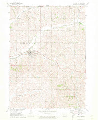
1971 Map of Charter Oak
USGS Topo · Published 1973About this map
Charter Oak stands at the heart of this Crawford County landscape, where the town’s civic and religious life is clearly mapped out through a cluster of local institutions. The convergence of the Middle Soldier River and East Soldier River creates a natural valley structure that defines the agricultural layout of the surrounding townships. Genealogical value is high here, with several burial sites located on the outskirts of the main settlement, including St John Cem, St Boniface Cem, and Charter Oak Cem.
Find a feature on this map
20 named features on this map. Tap any name to fly to it.
Don’t see what you’re looking for? This feature index may not catch every label — zoom into the map to look around manually.
Map Details
Editions of this 1971 Charter Oak Map
This is the sole edition of this map. No revisions or reprints were ever made.
Other maps of this area

1954 · Omaha
USGS Topo · 1:250,000

1954 · Fort Dodge
USGS Topo · 1:250,000

1957 · Omaha
USGS Topo · 1:250,000

1957 · Fort Dodge
USGS Topo · 1:250,000

1958 · Omaha
USGS Topo · 1:250,000

1958 · Fort Dodge
USGS Topo · 1:250,000

1969 · Danbury
USGS Topo · 1:24,000

1971 · Ricketts
USGS Topo · 1:24,000

1971 · Ute
USGS Topo · 1:24,000

1971 · Schleswig
USGS Topo · 1:24,000