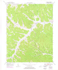
1949 Map of Charters
USGS Topo · Published 1978About this map
Salt Lick Creek carves a deep valley through the center of this Lewis County landscape, serving as the primary corridor for the era's infrastructure and settlement. Small communities and rural gathering points like Charters and Clarksburg are established along the water, while the surrounding highlands of Kentucky Ridge and Eskalapia Mtn remain defined by narrow hollows and steep timbered slopes. The map reveals a highly localized social geography, where isolated schools such as Heselton School and Holly School served families living deep within the drainage basins of Big Branch and Holly Branch. Genealogists will find significant value in the documentation of family-named burial sites, including Hackworth Cem and McCoy Cem, which are tucked away in the smaller hollows. The presence of a Pipe Line cutting across the ridges highlights the mid-century industrial expansion into this otherwise traditional Appalachian landscape.
Find a feature on this map
82 named features on this map. Tap any name to fly to it.
Don’t see what you’re looking for? This feature index may not catch every label — zoom into the map to look around manually.
Map Details
Editions of this 1949 Charters Map
3 editions found
Other maps of this area

1919 · Vanceburg
USGS Topo · 1:62,500

1929 · Springdale
USGS Topo · 1:48,000

1935 · Springdale
USGS Topo · 1:62,500

1949 · Vanceburg
USGS Topo · 1:62,500

1949 · Buena Vista
USGS Topo · 1:24,000

1949 · Vanceburg
USGS Topo · 1:24,000

1949 · Concord
USGS Topo · 1:24,000

1949 · Charters
USGS Topo · 1:24,000

1950 · Charters
USGS Topo · 1:24,000

1950 · Head Of Grassy
USGS Topo · 1:24,000