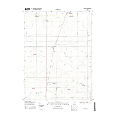
2013 Map of Chatfield
USGS Topo · Published 2013About this map
The village of Chatfield anchors this agricultural landscape in northern Crawford County, where the historic Columbus-Sandusky Rd cuts diagonally across the section lines. This corridor connects the primary settlements of Carrothers to the north and Ridgeton to the south, reflecting a legacy of rail-era transport and farm-to-market trade. The map is particularly dense with small, family and denominational burial grounds that reveal the area's pioneer genealogy, including the Coll Hill Reformed Cem, Nazareth Lutheran Cem, and the uniquely named Lust Cem. Waterways like Sycamore Cr and Broken Sword Cr meander through the townships, while Schulze's Airport provides a modern navigational reference point amidst the grid of rural township roads.
Find a feature on this map
57 named features on this map. Tap any name to fly to it.
Don’t see what you’re looking for? This feature index may not catch every label — zoom into the map to look around manually.
Map Details
Editions of this 2013 Chatfield Map
This is the sole edition of this map. No revisions or reprints were ever made.
Other maps of this area

1906 · Sycamore
USGS Topo · 1:62,500

1906 · Tiffin
USGS Topo · 1:62,500

1915 · Siam
USGS Topo · 1:62,500

1915 · Bucyrus
USGS Topo · 1:62,500

1943 · Bucyrus
USGS Topo · 1:62,500

1950 · Marion
USGS Topo · 1:250,000

1956 · Toledo
USGS Topo · 1:250,000

1960 · North Robinson
USGS Topo · 1:24,000

1960 · Oceola
USGS Topo · 1:24,000
1960 · Bloomville
USGS Topo · 1:24,000