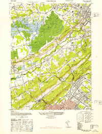
1947 Map of Chatham
USGS Topo · Published 1947About this map
The Great Swamp dominates the northern landscape of this 1947 survey, its expansive marshlands and brooks such as Black Brook providing a natural buffer between the burgeoning residential communities of Morris and Union Counties. To the south, the Passaic River snakes through a corridor of industry and transit, supporting a string of settlements including Gillette, Stirling, and Berkley Heights. This post-war era shows a region in transition, where large-scale institutions like the U S Veterans Hospital and the Bonnie Burn Sanatorium sit alongside an emerging network of recreational spaces and golf courses.
Find a feature on this map
63 named features on this map. Tap any name to fly to it.
Don’t see what you’re looking for? This feature index may not catch every label — zoom into the map to look around manually.
Map Details
Editions of this 1947 Chatham Map
2 editions found
Other maps of this area

1888 · Plainfield
USGS Topo · 1:62,500

1888 · Morristown
USGS Topo · 1:62,500

1888 · Lake Hopatcong
USGS Topo · 1:62,500

1891 · Somerville
USGS Topo · 1:62,500

1893 · Plainfield
USGS Topo · 1:62,500

1893 · Somerville
USGS Topo · 1:62,500

1894 · Morristown
USGS Topo · 1:62,500

1894 · Lake Hopatcong
USGS Topo · 1:62,500

1898 · Lake Hopatcong
USGS Topo · 1:62,500

1898 · Morristown
USGS Topo · 1:62,500