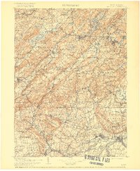
1905 Map of Raritan
USGS Topo · Published 1917About this map
Schooleys Mountain and the prominent ridges of the Watchung Mountains define the northern New Jersey interior during a period of significant industrial and transit development. The Morris Canal threads through the landscape alongside the Morris and Essex Railroad, illustrating the shift from water-based transport to heavy rail. This 1905 edition, based on earlier late-19th-century surveys, shows the region before the sprawl of the modern metropolitan area, preserving the layout of agricultural villages like White House Sta, Pottersville, and Oldwick (New Germantown). To the north, the Picatinny Arsenal stands as a notable federal presence, while recreational hubs at Lake Hopatcong and Budd Lake are already established. The convergence of the South Branch Raritan River and the North Branch Raritan River highlights the natural drainage patterns that dictated early mill placement and town sites like High Bridge.
Find a feature on this map
290 named features on this map. Tap any name to fly to it.
Don’t see what you’re looking for? This feature index may not catch every label — zoom into the map to look around manually.
Map Details
Editions of this 1905 Raritan Map
2 editions found

Other maps of this area

1888 · Franklin
USGS Topo · 1:62,500

1888 · Plainfield
USGS Topo · 1:62,500

1888 · Morristown
USGS Topo · 1:62,500

1888 · Hackettstown
USGS Topo · 1:62,500

1888 · New Brunswick
USGS Topo · 1:62,500

1888 · Princeton
USGS Topo · 1:62,500

1888 · Lake Hopatcong
USGS Topo · 1:62,500

1890 · Easton
USGS Topo · 1:62,500

1890 · High Bridge
USGS Topo · 1:62,500

1890 · Lambertville
USGS Topo · 1:62,500
Featured Places
- Franklin Township, NJ
- Parsippany-Troy Hills, NJ
- Piscataway Township, NJ
- Bridgewater Township, NJ
- Hillsborough Township, NJ