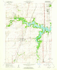
1961 Map of Chatham
USGS Topo · Published 1962About this map
The waters of Lake Springfield dominate the eastern landscape of this early 1960s survey, illustrating the significant recreational and infrastructural development south of the Illinois state capital. The village of Chatham serves as a primary inland hub, situated where the Gulf Mobile and Ohio and Illinois Terminal railroads converge. These rail lines, along with the Illinois Central to the east, define the local transport corridor through the townships of Woodside and Ball. Along the winding path of Sugar Creek, a Covered Bridge and several scouting camps, including Boy Scout Camp and Girl Scout Camp, indicate a landscape balanced between rural agriculture and organized community activity. Genealogists will find historical value in the locations of Stout Cem and St Bernard Cem, while the presence of the National Guard Depot and Southlawn neighborhood highlights the mid-century expansion of residential and military footprints.
Find a feature on this map
36 named features on this map. Tap any name to fly to it.
Don’t see what you’re looking for? This feature index may not catch every label — zoom into the map to look around manually.
Map Details
Editions of this 1961 Chatham Map
3 editions found
Other maps of this area

1907 · Springfield
USGS Topo · 1:62,500

1909 · Tallula
USGS Topo · 1:62,500

1922 · Divernon
USGS Topo · 1:62,500

1924 · Divernon
USGS Topo · 1:62,500

1924 · Waverly
USGS Topo · 1:62,500

1926 · Waverly
USGS Topo · 1:62,500

1930 · Springfield
USGS Topo · 1:62,500

1940 · Tallula
USGS Topo · 1:62,500

1940 · Springfield
USGS Topo · 1:62,500

1950 · Springfield West
USGS Topo · 1:24,000