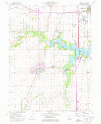
1961 Map of Chatham
USGS Topo · Published 1978About this map
Lake Springfield dominates the northeastern landscape of this mid-century survey, its expansive waters serving as a focal point for recreation and development south of the state capital. The map highlights the recreational importance of the shoreline, which hosted the YMCA Camp, Boy Scout Camp, and Girl Scout Camp, alongside the Cotton Hill Park. The village of Chatham sits at a critical junction of transportation, where the Gulf Mobile and Ohio railroad corridor runs parallel to Illinois 4.
Find a feature on this map
38 named features on this map. Tap any name to fly to it.
Don’t see what you’re looking for? This feature index may not catch every label — zoom into the map to look around manually.
Map Details
Editions of this 1961 Chatham Map
3 editions found
Other maps of this area

1907 · Springfield
USGS Topo · 1:62,500

1909 · Tallula
USGS Topo · 1:62,500

1922 · Divernon
USGS Topo · 1:62,500

1924 · Divernon
USGS Topo · 1:62,500

1924 · Waverly
USGS Topo · 1:62,500

1926 · Waverly
USGS Topo · 1:62,500

1930 · Springfield
USGS Topo · 1:62,500

1940 · Tallula
USGS Topo · 1:62,500

1940 · Springfield
USGS Topo · 1:62,500

1950 · Springfield West
USGS Topo · 1:24,000