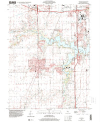
1998 Map of Chatham
USGS Topo · Published 2000About this map
Chatham and the southern reaches of Springfield serve as focal points for this late-century landscape, defined by suburban expansion and the recreational development of Lake Springfield. The lakefront is a hub of activity, featuring a cluster of youth camps including the YMCA Camp, Girl Scout Camp, and Boy Scout Camp, alongside the Boat Ramp and Cotton Hill Park. This map captures a significant period of infrastructure growth, evidenced by the intricate web of highway interchanges like Interchange 90 and the presence of the National Guard Depot and Lincoln Land Jr College.
Find a feature on this map
46 named features on this map. Tap any name to fly to it.
Don’t see what you’re looking for? This feature index may not catch every label — zoom into the map to look around manually.
Map Details
Editions of this 1998 Chatham Map
This is the sole edition of this map. No revisions or reprints were ever made.
Other maps of this area

1907 · Springfield
USGS Topo · 1:62,500

1909 · Tallula
USGS Topo · 1:62,500

1922 · Divernon
USGS Topo · 1:62,500

1924 · Divernon
USGS Topo · 1:62,500

1924 · Waverly
USGS Topo · 1:62,500

1926 · Waverly
USGS Topo · 1:62,500

1930 · Springfield
USGS Topo · 1:62,500

1940 · Tallula
USGS Topo · 1:62,500

1940 · Springfield
USGS Topo · 1:62,500

1950 · Springfield West
USGS Topo · 1:24,000