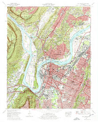
1969 Map of Chattanooga
USGS Topo · Published 1975About this map
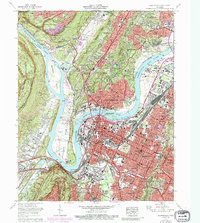
The Tennessee River dominates this mid-century portrait of the city, carving a deep loop around the prominent Moccasin Bend. This peninsula serves as a focal point for the region's complex history, containing both the Moccasin Bend Psychiatric Hospital and the northern reaches of the Chickamauga and Chattanooga National Military Park. To the east, the urban expansion of Chattanooga is densely mapped, showing the growth of neighborhoods like Highland Park and Bushtown toward the foot of Missionary Ridge. The map details the vital river-and-rail infrastructure that fueled the area's development, from the L & N RR lines to the numerous bars and shoals like Citico Bar and Lookout Shoals. Educational and civic landmarks are well-represented, including the University of Tennessee at Chattanooga and the National Cem, providing a clear view of the city's established 1960s footprint before further modern interstate development altered the local streetscape.
Find a feature on this map
118 named features on this map. Tap any name to fly to it.
Don’t see what you’re looking for? This feature index may not catch every label — zoom into the map to look around manually.
Map Details
Editions of this 1969 Chattanooga Map
6 editions found
Other maps of this area

1886 · Ringgold
USGS Topo · 1:125,000

1888 · Chattanooga
USGS Topo · 1:125,000

1892 · Ringgold
USGS Topo · 1:125,000

1893 · Chattanooga
USGS Topo · 1:125,000

1935 · East Chattanooga
USGS Topo · 1:24,000

1935 · Daisy
USGS Topo · 1:24,000

1935 · East Ridge
USGS Topo · 1:24,000

1936 · Ketner Gap
USGS Topo · 1:24,000

1936 · Hooker
USGS Topo · 1:24,000

1936 · Fort Oglethorpe
USGS Topo · 1:24,000