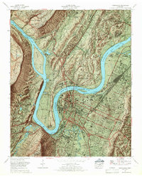
1969 Map of Chattanooga
USGS Topo · Published 1969About this map
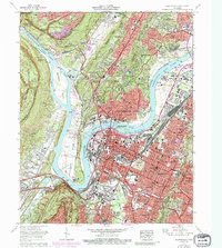
Nickajack Lake and the winding Tennessee River dominate this 1969 topographic portrait of a city defined by its dramatic relief. The urban core of Chattanooga is pinned between the Cumberland Escarpment to the west and Missionary Ridge to the east, showing a complex network of industrial rail yards like Cravens Yards and landmark bridges including the P R Olgiati Bridge and Walnut St Bridge. Significant institutions and parklands occupy the river's major bends, from the Moccasin Bend Psychiatric Hospital and Moccasin Bend Golf Course to the Audubon Society Wildlife Refuge Maclellan Island.
Find a feature on this map
138 named features on this map. Tap any name to fly to it.
Don’t see what you’re looking for? This feature index may not catch every label — zoom into the map to look around manually.
Map Details
Editions of this 1969 Chattanooga Map
6 editions found
Other maps of this area

1886 · Ringgold
USGS Topo · 1:125,000

1888 · Chattanooga
USGS Topo · 1:125,000

1892 · Ringgold
USGS Topo · 1:125,000

1893 · Chattanooga
USGS Topo · 1:125,000

1935 · East Chattanooga
USGS Topo · 1:24,000

1935 · Daisy
USGS Topo · 1:24,000

1935 · East Ridge
USGS Topo · 1:24,000

1936 · Ketner Gap
USGS Topo · 1:24,000

1936 · Hooker
USGS Topo · 1:24,000

1936 · Fort Oglethorpe
USGS Topo · 1:24,000