
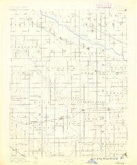
1889 Map of Cheney
USGS Topo · Published 1889About this map
The Arkansas River and the Ninnescah River systems dominate this late-nineteenth-century landscape, carving through a grid-iron pattern of township sections. This area shows a transition from river-dependent settlements to rail-oriented trade centers, with early post offices like Stella P.O. and Mona P.O. dotting the interior while growing towns such as Cheney and Garden Plain anchor the Wichita and Western Railroad. Northward, the St. Louis and San Francisco Railroad connects Mt. Hope and Bentley to the broader regional economy.
Find a feature on this map
76 named features on this map. Tap any name to fly to it.
Don’t see what you’re looking for? This feature index may not catch every label — zoom into the map to look around manually.
Map Details
Editions of this 1889 Cheney Map
2 editions found
Other maps of this area

1889 · Newton
USGS Topo · 1:125,000

1889 · Anthony
USGS Topo · 1:125,000

1889 · Wichita
USGS Topo · 1:125,000

1889 · Caldwell
USGS Topo · 1:125,000

1890 · Wellington
USGS Topo · 1:125,000

1891 · Hutchinson
USGS Topo · 1:125,000

1891 · Cheney
USGS Topo · 1:125,000

1891 · Anthony
USGS Topo · 1:125,000

1892 · Kingman
USGS Topo · 1:125,000

1893 · Caldwell
USGS Topo · 1:125,000