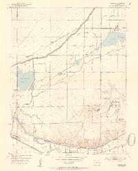
1953 Map of Cheraw
USGS Topo · Published 1954About this map
Cheraw Lake and the town of Cheraw anchor this mid-century portrait of Otero County’s irrigated agricultural landscape. The region’s reliance on complex water management is evident in the sprawling network of the Fort Lyon Storage Canal and Holbrook Reservoir, which supported local industry including a Sugar Refinery near the Arkansas River. The influence of the Atchison Topeka and Santa Fe railway is prominent, serving a series of small sidings and communities like Orr, Randall, and Shelton. Near the southern bend of the river, the map details the suburban development of North La Junta and La Junta Gardens, while the La Junta Municipal Airport and La Junta Village occupy the higher ground to the east, illustrating the area's growth as both a transit hub and a farming center.
Find a feature on this map
32 named features on this map. Tap any name to fly to it.
Don’t see what you’re looking for? This feature index may not catch every label — zoom into the map to look around manually.
Map Details
Editions of this 1953 Cheraw Map
4 editions found
Other maps of this area

1891 · Catlin
USGS Topo · 1:125,000

1891 · Higbee
USGS Topo · 1:125,000

1891 · Las Animas
USGS Topo · 1:125,000

1891 · Timpas
USGS Topo · 1:125,000

1893 · Higbee
USGS Topo · 1:125,000

1893 · Las Animas
USGS Topo · 1:125,000

1893 · Catlin
USGS Topo · 1:125,000

1894 · Timpas
USGS Topo · 1:125,000

1953 · Cheraw
USGS Topo · 1:24,000

1953 · Hadley
USGS Topo · 1:24,000