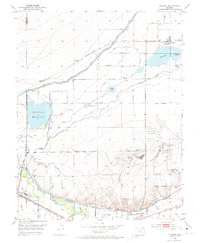
1953 Map of Cheraw
USGS Topo · Published 1974About this map
The Arkansas River serves as the focal point of this irrigation-dependent landscape, where a sophisticated network of water engineering supports agriculture in the high plains. The Fort Lyon Canal and Fort Lyon Storage Canal move water across the terrain to fill substantial basins like Holbrook Reservoir and Cheraw Lake. This 1953 survey captures the area's mid-century industrial and residential footprint, including the Sugar Refinery near the river and the development of La Junta Village and La Junta Gardens. The Atchison Topeka and Santa Fe railroad corridor remains the primary transport spine, connecting the village of Cheraw with the larger regional hubs. Geographers and local historians will find the detailed footprint of the La Junta Municipal Airport and the placement of the Holbrook Cemetery particularly valuable for tracing the physical evolution of Otero County.
Find a feature on this map
23 named features on this map. Tap any name to fly to it.
Don’t see what you’re looking for? This feature index may not catch every label — zoom into the map to look around manually.
Map Details
Editions of this 1953 Cheraw Map
4 editions found
Other maps of this area

1891 · Catlin
USGS Topo · 1:125,000

1891 · Higbee
USGS Topo · 1:125,000

1891 · Las Animas
USGS Topo · 1:125,000

1891 · Timpas
USGS Topo · 1:125,000

1893 · Higbee
USGS Topo · 1:125,000

1893 · Las Animas
USGS Topo · 1:125,000

1893 · Catlin
USGS Topo · 1:125,000

1894 · Timpas
USGS Topo · 1:125,000

1953 · Cheraw
USGS Topo · 1:24,000

1953 · Hadley
USGS Topo · 1:24,000