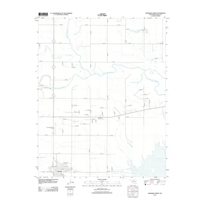
2012 Map of Cherokee North
USGS Topo · Published 2012About this map
Cherokee serves as the focal point of this northern Alfalfa County landscape, where the confluence of several significant waterways dictates the local geography. The Salt Fork Arkansas River winds through the central portion of the map, joined by the Medicine Lodge River and smaller tributaries like Driftwood Cr and Cottonwood Cr. The grid of the township is clearly established by a series of numbered roads, including e0180 RD and n2615 RD, which connect the town to outlying landmarks. Genealogists and local historians will find the Stella Friends Acad Cem north of town, a site associated with the region's Quaker educational history. The infrastructure of the early 21st century is represented by the Cherokee Municipal Airport and the surrounding transport network, showing how the settlement has maintained its position as a regional hub even as the agricultural landscape around it remained largely open.
Find a feature on this map
60 named features on this map. Tap any name to fly to it.
Don’t see what you’re looking for? This feature index may not catch every label — zoom into the map to look around manually.
Map Details
Editions of this 2012 Cherokee North Map
This is the sole edition of this map. No revisions or reprints were ever made.
Other maps of this area

1955 · Woodward
USGS Topo · 1:250,000

1958 · Woodward
USGS Topo · 1:250,000

1969 · Jet
USGS Topo · 1:24,000

1969 · Lambert
USGS Topo · 1:24,000

1969 · Amorita
USGS Topo · 1:24,000

1969 · Burlington
USGS Topo · 1:24,000

1969 · Manchester SW
USGS Topo · 1:24,000
1969 · Manchester NW
USGS Topo · 1:24,000

1969 · Cherokee North
USGS Topo · 1:24,000

1969 · Ingersoll
USGS Topo · 1:24,000