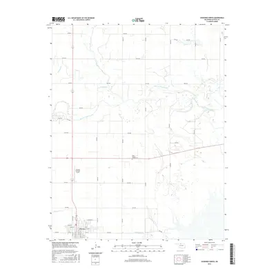
2016 Map of Cherokee North
USGS Topo · Published 2016About this map
Cherokee serves as the focal point of this northern Oklahoma survey, situated at the intersection of a grid-like road network and southern watercourses. The town's layout is clearly defined by a series of numbered and named streets, such as W Main St and S Ohio Ave, while the Cherokee Municipal Airport provides a modern transportation hub to the north of the main settlement. The landscape is dominated by the complex drainage patterns of the Salt Fork Arkansas River, which meanders across the central portion of the sheet, joined by Medicine Lodge River and Driftwood Cr. To the northeast of the town center, the Stella Friends Academy Cem offers a point of interest for genealogists and local historians, marking a site of community memory amidst the agricultural landscape of Alfalfa County.
Find a feature on this map
40 named features on this map. Tap any name to fly to it.
Don’t see what you’re looking for? This feature index may not catch every label — zoom into the map to look around manually.
Map Details
Editions of this 2016 Cherokee North Map
This is the sole edition of this map. No revisions or reprints were ever made.
Other maps of this area

1955 · Woodward
USGS Topo · 1:250,000

1958 · Woodward
USGS Topo · 1:250,000

1969 · Jet
USGS Topo · 1:24,000

1969 · Lambert
USGS Topo · 1:24,000

1969 · Amorita
USGS Topo · 1:24,000

1969 · Burlington
USGS Topo · 1:24,000

1969 · Manchester SW
USGS Topo · 1:24,000
1969 · Manchester NW
USGS Topo · 1:24,000

1969 · Cherokee North
USGS Topo · 1:24,000

1969 · Ingersoll
USGS Topo · 1:24,000