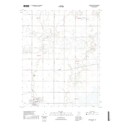
2018 Map of Cherokee North
USGS Topo · Published 2018About this map
Cherokee serves as the focal point for this section of Alfalfa County, its grid of streets such as N Grand Ave and E Jefferson St marking the urban center. Just north of the settlement, the Cherokee Municipal Airport occupies the flat prairie, reflecting the modern infrastructure of this rural Oklahoma landscape. The terrain is defined by the convergence of several significant waterways, most notably the Salt Fork Arkansas River and the Medicine Lodge River, which meander through the northern reaches of the quadrangle. For those researching local history, the Stella Friends Academy Cem stands as a quiet landmark between the town and the river valleys. The landscape remains divided into a vast agricultural grid, connected by numbered section roads like E0140 Rd that navigate the drainages of Cottonwood Cr and Driftwood Cr.
Find a feature on this map
48 named features on this map. Tap any name to fly to it.
Don’t see what you’re looking for? This feature index may not catch every label — zoom into the map to look around manually.
Map Details
Editions of this 2018 Cherokee North Map
This is the sole edition of this map. No revisions or reprints were ever made.
Other maps of this area

1955 · Woodward
USGS Topo · 1:250,000

1958 · Woodward
USGS Topo · 1:250,000

1969 · Jet
USGS Topo · 1:24,000

1969 · Lambert
USGS Topo · 1:24,000

1969 · Amorita
USGS Topo · 1:24,000

1969 · Burlington
USGS Topo · 1:24,000

1969 · Manchester SW
USGS Topo · 1:24,000
1969 · Manchester NW
USGS Topo · 1:24,000

1969 · Cherokee North
USGS Topo · 1:24,000

1969 · Ingersoll
USGS Topo · 1:24,000